Typhoon No. 3 is forecast to be very strong, posing a high risk of natural disaster, and having a complex trajectory.Official dispatch sent to the Secretaries and Chairmen of the People's Committees of the provinces and cities of: Quang Ninh, Hai Phong, Thai Binh, Nam Dinh, Ninh Binh, Thanh Hoa, Nghe An, Ha Tinh, Quang Binh, Quang Tri, Thua Thien Hue, Da Nang, Quang Nam, Quang Ngai, Binh Dinh, Lang Son, Cao Bang, Bac Kan, Thai Nguyen, Ha Giang, Lao Cai, Yen Bai, Tuyen Quang, Phu Tho, Vinh Phuc, Dien Bien, Lai Chau, Son La, Hoa Binh, Hanoi, Ha Nam, Hung Yen, Hai Duong, Bac Ninh, Bac Giang; and the Ministers of the Ministries of: National Defence, Public Security, Natural Resources and Environment, Agriculture and Rural Development, Industry and Trade, Transport, Construction, Foreign Affairs, Information and Communications, Education and Training, Health, Culture, Sports and Tourism.
The official dispatch stated: This morning (September 5, 2024), Typhoon No. 3 has strengthened into a super typhoon, with the strongest winds near the center reaching level 16, gusting above level 17.
Forecasts indicate that from tomorrow morning, the storm will directly affect the Gulf of Tonkin with maximum wind speeds near the storm's center reaching levels 13-14, gusting to level 16; from tomorrow night, it will directly affect the mainland of the Northeast and North Central regions of Vietnam with maximum wind speeds possibly reaching levels 10-12, gusting to levels 13-14, and penetrating deep inland. The storm is likely to cause strong winds, storm surges, large waves at sea and along the coast, and widespread strong winds and heavy rain inland.
With Typhoon No. 3 forecast to be very strong, posing a high risk of natural disaster, and having a complex trajectory, the Prime Minister requests:
Firstly, the Ministers of the Ministries, Secretaries and Chairmen of the People's Committees of the aforementioned localities should focus on leading, directing, organizing inspections, urging, and implementing decisively, promptly, and effectively the work of preventing and responding to storms with the spirit of proactively preventing and responding at the highest level to ensure the safety of lives, especially children and vulnerable groups, and to minimize damage to the property of the people and the State.
Postpone non-urgent meetings and mobilize the entire political system to combat the storm.
Secondly, the Secretaries and Chairmen of the People's Committees of the aforementioned provinces and centrally-administered cities should postpone non-urgent meetings, mobilize the entire political system, and assign each member of the Standing Committee and the Standing Board of the People's Committee to directly go to key areas to lead, direct, supervise, and inspect the work of storm and flood prevention and control, focusing on:
Thoroughly review and immediately implement measures to ensure safety for activities at sea and on islands; ensure the safety of people, ships, and vessels operating at sea (especially ships in the Gulf of Tonkin and along the coast from Ha Tinh northward) and at shelters.
Ensuring the safety of people's lives in dangerous areas, especially on floating cages, aquaculture watchtowers, boats in shelters, areas at risk of deep flooding due to large waves, rising water levels, heavy rain, and areas at risk of landslides and flash floods that are not safe, resolutely preventing people from remaining in dangerous areas when the storm directly affects and heavy rains and floods occur (if necessary, proactively enforce relocation to ensure the safety of people's lives).
Directing efforts to ensure the safety of dikes, dams, and reservoirs; traffic safety; minimizing damage to houses, warehouses, offices, public works, industrial zones, factories, and enterprises; protecting agricultural production; and preventing flooding in urban and industrial areas.
Proactively deploy forces and resources in key vulnerable areas to be ready to promptly handle any situations that may arise during storms and floods.
Consider holding the heads of organizations, agencies, and units accountable for negligence and complacency in carrying out storm and flood prevention and control tasks; strictly penalize business owners, vehicle operators, boat owners, and fish cage owners who fail to comply with directives from competent authorities and forces in storm prevention and control work.
The Party Secretary and Chairman of the People's Committee at the provincial level will be held accountable to the Party Central Committee and the Prime Minister if they are negligent or careless in leadership and direction, or slow in implementing responses to storms and floods, leading to significant losses of life and property.
Urgently review and update response plans based on the level of storm risk.
Thirdly, the Minister of National Defence and the Minister of Public Security shall direct relevant units to urgently review and update response plans according to the level of risk of the storm, proactively deploy forces and resources to coordinate with relevant forces to implement storm and flood prevention and control work as prescribed.
Other ministries and agencies, according to their assigned state management functions, shall continue to direct and implement seriously and effectively the work of storm prevention and control as directed by the Prime Minister in Official Dispatch No. 86/CĐ-TTg dated September 3, 2024.
Fourth, the Minister of Agriculture and Rural Development will organize a 24/7 duty roster to closely monitor the situation, proactively direct and urge localities to implement response measures appropriate to the actual developments of natural disasters, and promptly report and propose to the Prime Minister for guidance on issues beyond their authority.
Fifth, Deputy Prime Minister Tran Hong Ha is tasked with directly instructing ministries, sectors, and localities to continue implementing timely and effective measures to respond to and mitigate the consequences of Typhoon No. 3 and the subsequent floods.
Sixth, the Government Office will monitor and urge the implementation of this Directive, and promptly report to the Prime Minister and the Deputy Prime Minister in charge of any unforeseen or emerging issues.
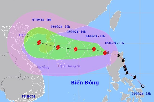
Typhoon No. 3 (Super Typhoon Yagi) has gusts exceeding level 17, located 460 km from Hainan Island (China).
On September 3rd, Typhoon Yagi entered the northeastern waters of the South China Sea, becoming the third typhoon of 2024.
According to the National Center for Meteorological and Hydrological Forecasting, on the morning of September 5th, Typhoon No. 3 continued to strengthen to level 16 (super typhoon level).
At 4 PM on September 5th, the center of the super typhoon was located at approximately 19.3 degrees North latitude and 114.7 degrees East longitude, in the northern part of the South China Sea, about 400km east of Hainan Island (China).
The strongest winds near the center of the super typhoon reached level 16 (184-201 km/h), with gusts exceeding level 17, moving westward at a speed of approximately 12 km/h.
Forecast of the development of Typhoon No. 3 (Super Typhoon YAGI) in the next 24 to 72 hours.
|
Forecast time
|
Direction, speed
|
Location
|
Intensity
|
Hazardous area
|
Level of natural disaster risk (Affected area)
|
|
4 PM/06/9
|
West-northwest, approximately 15 km/h
|
20.1N-111.4E; in the sea area northeast of Hainan Island (China), about 450km east-southeast of Quang Ninh.
|
Level 16, bursts above level 17.
|
North of latitude 16.0N; longitude 108.5E – 118.0E
|
Level 4: Northern part of the North East Sea region
|
|
4 PM/07/9
|
West-northwest, approximately 20 km/h and gradually weakening.
|
21.1N-107.0E; on the mainland coast from Quang Ninh to Nam Dinh
|
Level 10-11, bursts up to level 14.
|
North of latitude 16.0N; west of longitude 114.0E
|
Level 4: East of the northern Gulf of Tonkin. Level 3: West of the northern Gulf of Tonkin and South of the Gulf of Tonkin.
|
|
4 PM/08/9
|
West-northwest, approximately 20 km/h, gradually weakening into a low-pressure area.
|
22.0N-102.5E; over the northwestern region of Northern Vietnam.
|
< level 6
|
North of latitude 17.0N; West of longitude 109.5E
|
Level 3: Gulf of Tonkin
|
Forecast of the impact of Typhoon No. 3 (Super Typhoon Yagi)At sea: In the northern South China Sea, winds will be strong, reaching levels 11-14, with winds near the center of the super typhoon reaching levels 15-16, gusting above level 17; the sea will be extremely rough.
From around noon on September 6th, the eastern part of the Gulf of Tonkin (including Bach Long Vy island district) experienced increasingly strong winds, reaching levels 6-7.
From the evening and night of September 6th, the Gulf of Tonkin area (including Bach Long Vy and Co To island districts) will experience increasingly strong winds, reaching levels 8-9, then increasing to levels 10-12, with winds near the storm's center reaching levels 13-14, gusting to level 17; the sea will be extremely rough.
On land: From the night of September 6th and early morning of September 7th, coastal areas from Quang Ninh to Thanh Hoa will experience gradually increasing winds of force 6-7, then increasing to force 8-9, with winds near the storm's center reaching force 10-12, gusting to force 14; inland areas of the Northeast will experience strong winds of force 6-8, gusting to force 9-11 (the strongest winds will occur from noon to evening on September 7th).
Sea waves: In the northern South China Sea, sea waves will be 7.0-9.0m high, and near the center of the super typhoon, they will reach 10.0-12.0m. The sea will be extremely rough.
From noon on September 6th, the Gulf of Tonkin area (including Bach Long Vy and Co To island districts) experienced waves of 2.0-4.0m, later increasing to 3.0-5.0m, and reaching 6.0-8.0m in the area near the storm's center.
From the night of September 6th and early morning of September 7th, the coastal waters from Quang Ninh to Thanh Hoa experienced waves of 2.0-3.0m, later increasing to 2.0-4.0m, and 3.0-5.0m near the storm's center.
Storm surge/retreat: Coastal areas from Thanh Hoa to Quang Ninh need to be prepared for storm surges of 0.5m (Thanh Hoa) - 1.8m (Quang Ninh) in the afternoon and night of September 7th, and storm recedes of 0.5m (Thanh Hoa) - 1.0m (Quang Ninh) in the morning of September 7th.
The areas where boats are moored, aquaculture farms, and sea dikes and embankments in the aforementioned hazardous zone are all susceptible to the impact of strong winds, large waves, and storm surges/retreats.
Low-lying coastal and estuarine areas should be wary of flooding due to rising water levels and large waves.
From the night of September 6th to the morning of September 9th, the Northern region and Thanh Hoa province are likely to experience a period of heavy rain, with localized areas experiencing very heavy rain and thunderstorms. The total rainfall is expected to be between 100-350mm, with some areas exceeding 500mm (the heaviest rainfall in the Northeast region will be concentrated during the day and night of September 7th; in the Northwest region, it will be from the evening of September 7th to the night of September 8th).
Heavy rains are likely to cause flooding in low-lying areas; flash floods on small rivers and streams, and landslides on slopes.
Due to the influence of the wide storm circulation, there is a risk of thunderstorms, tornadoes, and strong gusts of wind both before and during the landfall of Typhoon No. 3.
The worrying issue is thunderstorms preceding the storm.
Earlier, on the afternoon of September 4th, the General Department of Meteorology and Hydrology, Ministry of Natural Resources and Environment, held a briefing on Typhoon No. 3 (YAGI).
According to experts, Typhoon No. 3 is a very strong storm with a wide circulation, so even before moving into the Gulf of Tonkin, it could still cause strong thunderstorms and lightning strikes in Vietnam.
Specifically, according to experts, the current concern is the thunderstorms preceding the typhoon. On September 6th, while Typhoon No. 3 is still over Hainan Island, the Vietnamese mainland, particularly the Northern region, is likely to experience thunderstorms accompanied by tornadoes and lightning.
In the early morning and midday of September 7th, coastal provinces will experience heavy rain and increasingly strong winds. The rain and wind will concentrate around late afternoon and continue into September 8th, then gradually decrease and shift towards the Northwest region.
The northern and north-central provinces will be directly affected by the storm, experiencing strong winds of level 6 or higher accompanied by heavy rain. The storm's center (strongest winds, heaviest rain) will be in the provinces of Quang Ninh, Hai Phong, Thai Binh, Nam Dinh, and Ninh Binh.
Heavy rainfall concentrated over a short period poses a high risk of landslides and flash floods in these areas. More specific information will be provided in subsequent news reports – Mr. Lam stated.
According to Mr. Nguyen Xuan Hien, Director of the Oceanographic Center, General Department of Meteorology and Hydrology, in the next 24 hours, sea waves in the northern part of the East Sea could reach a height of 5-7 meters, and in the area where the storm passes, they could reach 7-10 meters.
With forecasts predicting a super typhoon intensity, Typhoon No. 3 could cause waves 10-12 meters high in the area near the storm's center.
Forecasts indicate that even after the storm enters the Gulf of Tonkin and weakens, waves will still be 5-7 meters high, posing a danger to ships even when they have entered safe harbors or anchorages.
In addition, storm surges from Typhoon No. 3 could reach 1.5 meters, posing a danger to low-lying areas, especially when combined with high waves. Coastal provinces from Quang Ninh to Ha Tinh, which are affected by the typhoon, need to be extremely cautious due to the impact of high waves and strong winds.
Hanoi is expected to begin experiencing the effects of Typhoon No. 3 starting from September 7th.
Regarding Hanoi specifically, Mr. Dinh Huu Duong, Head of the Forecasting Department of the Northern Delta and Midlands Meteorological Station, informed: It is expected that from September 7th, Hanoi will begin to be affected by typhoon number 3. The wind will gradually strengthen to level 5, level 6, and the strongest will be level 7, with gusts up to level 9.
A period of heavy, concentrated rainfall is expected around September 7-8, but there may have been sudden, strong thunderstorms beforehand due to the influence of the storm's circulation.
The rain will also be concentrated in a short period of time, which is likely to cause flooding in the inner city and low-lying suburban areas.
With heavy rainfall, the Bui, Tich, and Ca Lo rivers may experience floods reaching alert level 3, causing prolonged flooding in some communes of Chuong My district such as Tot Dong and Nam Phuong Tien. Specific information will be updated in subsequent news reports.
Emphasizing the response efforts, experts believe the most important thing is for people to comply with the requirements of the Disaster Prevention and Control Steering Committee from the central to local levels. The immediate priority is ensuring safety at sea and reviewing vulnerable points on land. As the storm approaches the shore, the authorities will issue more detailed instructions.